Mamainse Hill
Posted by Derek on Nov 7, 2015
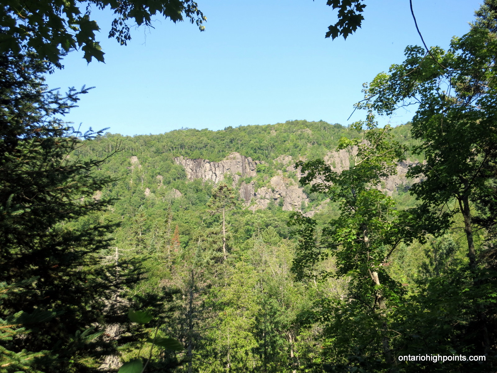
Mamainse Hill
GPS recorded height: 1958 feet / 597 meters
Lat/Lon: N47 01.592 W84 36.474
Date Summited: July 26, 2015
Overview:
Mamainse Hill is a prominent hill located 10 km north of Batchawana Bay, Lake Superior. It is flanked by steep pitches on 3 sides with high cliffs on the east and south sides. When viewed from nearby Carp Lake Road these cliffs are imposing and impressive. It is a treed summit, but it is a short bushwhack to the good views on top of the eastern cliffs.
Peak 564
Posted by Derek on May 8, 2015
aka. Western Uplands Trail High Point
Height: 1850 feet / 564 m
GPS recorded height: 1894 feet / 577 m
Lat/Lon: N45 34.047 W78 49.948
Date Summited: May 2, 2015
Overview:
Peak 564 is a high hill in Algonquin Park and the 2nd highest point in Southern Ontario. The hill is adjacent to the midpoint along the 2nd Loop of the Western Uplands Trail, near Tern Lake. With it’s close proximity to a well established backpacking trail, it is a possible multi-day hike destination. Alternatively, one can reach the peak in a long day hike from Arowhon Road (detailed below). There are no views from the broad treed summit, but hikers can enjoy the vistas along many of the lakes and ponds on the approach.
Grey Owl Peak
Posted by Derek on Dec 12, 2014

Grey Owl Peak
Height: 2103 feet / 641 meters
Lat/Lon: N47.2503 W84.2273
Clean Prominence: 489 feet / 149 meters
Line Parent: Alvin Lake Peak
Key Col: N47 15.028 W84 14.486 (1411ft / 430m)
GPS recorded height: 2102 feet / 641 meters
Date Summited: August 15, 2014
Overview:
Grey Owl peak, named after nearby Grey Owl Lake (2 km west) is a remote Algoma Peak which affords outstanding views of the area. From the summit, many of the high Algoma hills are visible, including Alvin Lake Peak, Ogidaki Mt., Griffin Lake Peak and Batchawana Mt. Even though the Peak is less than a 1 km bushwhack from a road*, due to the distance from from a major road (55.8 km away from Hwy 17), it is a difficult mountain to access. As the Ontario Basic Mapping (OBM) series maps show a 640 meter contour at the summit, this peak meets the Ontario 2100 footer list criteria.
* Mile 38 Road becomes a 2-track road north of the Batchawana River
Mount Baldy
Posted by Derek on Nov 18, 2014

Mount Baldy as seen from Crossover Road
GPS recorded height: 2014 feet / 614 meters
Lat/Lon: N47 44.471 W84 18.407
Date Summited: August 14, 2014
Overview:
Located 44 km southeast of Wawa, Mount Baldy is a prominent hill which rises above the nearby Agawa River. The bare rock summit is crowned by an old fire tower. Unlike most peaks in Ontario, Mount Baldy provides unencumbered 360 degree views. It is a short bushwhack to the summit from nearby Crossover Road.
Kwagama Hill
Posted by Derek on Oct 20, 2014

Kwagama Hill in the background
Lat/Lon: N47.4147 W84.5589
Clean Prominence: 978 feet / 298 meters
Line Parent: Blackspruce Lake Peak
Key Col: N47 36.949 W84 31.633 (1115ft / 340m)
GPS recorded height: 2099 feet / 640 meters
Date Summited: August 13, 2014
Overview:
Kwagama Hill is a mountain 6 km due west of the popular Algoma tourist attraction, the Agawa Canyon, which is serviced by the Agawa Canyon Train Tour from Sault Ste Marie. Even though the area is fairly popular for backcountry excursions, there are very few trips up to Kwagama Hill. There was a fire tower on the summit of the peak, however it was knocked down in a heavy ice storm in 1965. The twisted metal remains are still visible today. The summit of Kwagama Hill affords outstanding views west to Lake Superior. Read the rest of this entry »
Silver Peak – Overland
Posted by Derek on May 25, 2014

Silver Peak Ridge
Lat/Lon: N46 06.662 W81 17.357
Date Summited: May 18, 2014
Overview:
Located in Killarney Provincial Park, Silver Peak is the pinnacle of the La Cloche Mountains, a weathered 3.5 billion year old mountain range that was once higher than today’s Rocky Mountains. The peak is so named because of the silvery gleam the white quartzite gives off in the sunshine. Although not the highest elevation in Ontario, the peak is well regarded for it’s mountainous terrain and sweeping views, and as such is a popular hiking destination.
Read the rest of this entry »
Kwagama Hill – Winter Ascent
Posted by Derek on Apr 9, 2014
Height: 2093 feet / 638 meters
Lat/Lon: N47.4147 W84.5589
Clean Prominence: 978 feet / 298 meters
Line Parent: Blackspruce Lake Peak
Key Col: N47 36.949 W84 31.633 (1115ft / 340m)
Overview:
Kwagama Hill is a mountain 6 km due west of the popular Algoma tourist attraction: The Agawa Canyon, which is serviced by the Agawa Canyon Train Tour out of Sault Ste Marie. The area is fairly popular for backcountry excursions and because of this, there occasional trips up Kwagama Hill. There was a fire tower on the summit of the peak, however it was knocked down in a wind storm many years ago. The twisted metal remains are still visible today. The summit of Kwagama Hill affords outstanding views including west to Lake Superior.
Read the rest of this entry »
Sister Lake Peak
Posted by Derek on Oct 19, 2013
aka.: Peak 579 (no official name)
Height: 1900 feet / 579 meters
GPS recorded height: 1912 feet / 583 meters
Lat/Lon: N46 38.074 W82 34.898
Date Summited: October 12, 2013
Overview:
Sister Lake Peak (Unofficial name) is the highest point in the Rawhide / Mississagi Provincial Park area, a region north of Elliot Lake. The peak marks the highest point along a ridge formation which includes nearby peaks: Thunder Mountain and Mt. Belvedere. An Ontario MNR survey monument marks the highest point on the peak. Although the summit is open — atop exposed bedrock, there are no views at the summit. There are however, partial views on route to the peak.
Directions:
From the intersection with Hwy. 17 at Serpent River, take Hwy. 108 north to Elliot Lake for 27 km. Continue north along Hwy. 108 through Elliot Lake. At Quirke Mine Road, 42 km from Hwy 17, Hwy. 108 becomes Secondary Highway 639. Continue northward along the road for 17.4 km and pass through Mississagi Provincial Park. Just past the northern boundaries of Mississagi, you will arrive at Boland River Road. Turn right onto the well groomed sand and gravel road and follow it east for 18.1 km until reaching a turn off with a quad trail which heads north (left) from the road. Parking is best about 100 meters before the intersection (west) with the quad trail at the crest of a hill alongside the road.
The hike begins along a farily well traveled quad path which heads up the ridge from Boland River Road. Turn right (east) at each of the 2 3-way intersections on route (at 1.3 and 1.6 km respectively). The trail becomes more and more overgrown and eventually ends at 2.1 km. The remaining 600 meters must be bushwhacked, alternating between difficult tag alder bush and more open deciduous forest. The summit area is in a rocky clearing and the highest point is marked by an Ontario Natural Resources survey marker dated 1977. Read the rest of this entry »
Mt. Belvedere
Posted by Derek on Oct 18, 2013

Mt. Belvedere
GPS recorded height: 1774 feet / 541 meters
Lat/Lon: N46 38.799 W82 47.678
Date Summited: October 12, 2013
Overview:
Mt. Belvedere is a prominent hill in the Rawhide Conservation Reserve, north of Elliot Lake. It is a short hike (1.5 km) via the Cobre Lake Trail, to the open summit with its spectacular views of the lakes and hills in the area. Hikers have the option to hike the entire 12.8 km Cobre Lake loop trail through forests containing old growth red and white pines, picturesque blue lakes with sand beaches, and artifacts of the area’s mining days.
Directions:
From the intersection with Hwy. 17 at Serpent River, take Hwy. 108 north to Elliot Lake for 27 km. Continue north along Hwy. 108 through Elliot Lake. At Quirke Mine Road, 42 km from Hwy 17, Hwy. 108 becomes Secondary Highway 639. Continue northward along the road for 20 km and pass through Mississagi Provincial Park. The turnoff to the Cobre Lake Trail parking lot lies 62 km from the junction with Hwy 17, just as the road starts to descend into the Little White River valley. Turn right onto the short rough road and make your way east for 250 meters and then turn left at the 3 way intersection and head north for a further 250 meters to the parking area.
Read the rest of this entry »
The Crack
Posted by Derek on Aug 17, 2013

The Crack
Lat/Lon: N46 03.681 W81 20.908
Date Summited: August 5, 2013
Overview:
The Crack is a stunning steep sided crevasse slicing through a quartzite rock cliff, located Killarney Provincial Park. The destination is popular with hikers for the iconic Killarney views of pristine lakes framed by the white quartzite La Cloche mountains. A recently opened access trail on Highway 637 allows day hikers a short, but rugged hike to top of the ridge.